
Hiking Europe’s Hardest Walking Trail
It is considered Europe’s toughest walking trail – the mythical, challenging GR20 route that slices through Corsica. Hike it and discover there is more to the island than gorgeous beaches.
“You are ascending 600m in 2km… are you climbing a wall?!” The text emitted disbelief, as if I must be making it all up. I had just begun the second day of my four-day journey on the northernmost part of the GR20 hiking trail in Corsica, and my friend’s text, in reply to the itinerary I’d shared with him, came just as I was about to do exactly that. Climb a wall. “I would not call that hiking,” came the final reply.
Commonly considered Europe’s most difficult hike this Grande Randonnée (hence the ‘GR’ in GR20), is known locally as Fra li Monti, which means ‘across the mountains’ in the Corse language. It stretches 112 miles (180km) from the town of Conca at the southern end of the island to Calenzana in the northwest, traversing high plateaus and dipping low into valleys across ground that is exposed to the harsh elements.
The full trail usually takes a little over two weeks. For the sake of time, I wanted to sample just the finest parts of this legendary route, which meant choosing its most difficult northern sections to complete.
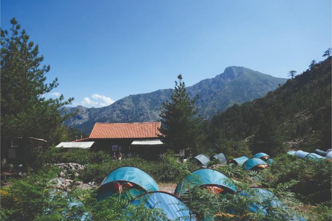
Camping at Auberge u Vallone
A mountain in the sea
On a clear sunny day, Corsica seems to be saturated with all shades of colour. The Île de Beauté, as it’s affectionately known, is surrounded by beaches of lustrous white sand washed gently with the pale sapphire blue of the sea – it’s little surprise that most people come here for the coastline. I caught a glimpse of the glorious Mediterranean on the drive from the airport to my starting point at the Hôtel Castel di Vergio, from where the next day I would hike north back towards Calvi. The sight was alluring and postcard perfect: this coastline is a sunseeker’s playground, from family resorts offering beach-access rooms and full-board menus to the more secluded bays where the rich and famous have their own private estates and yachts.
My driver was on and off phone calls, animatedly chatting away in Corse as we sped through the coastal areas before having to slow down as the roads narrowed to single lanes that wind into the mountains. Wedged between high cliffs on one side and a ravine on the other, I was treated to a preview of the hike I was about to embark on.
The Île de Beauté is often described as ‘a mountain in the sea’, and the abrupt rise of the mountain ranges from the coastline makes for dramatic scenery. We drove on deeper into this breathtaking, rocky interior until the sea disappeared from view. There was no turning back now.
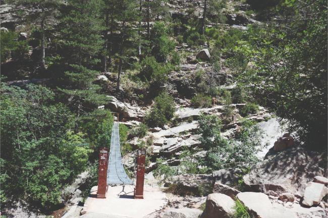
Footbridge crossing a small canyon along the GR20
No ordinary hike
I arrived at Castel di Vergio late in the afternoon. Europe was experiencing a unprecedented heatwave and I felt the sizzling sun threatening the rest of the week. Picking a shady spot, I ordered a cold drink to cool down on the terrace and listened to the conversations happening around me.”…it was so steep, I couldn’t even come down normally… I was scared I would break a leg… You really need to focus when you come across these sections… This is my second time… it doesn’t get easier… I hear a top trail runner did the whole course in less than 40 hours…” For the majority of people, this would be the last stages of their journey if they were following the GR20 from the south to north. I guessed my fellow guests had been on the trail for more than a week by now, judging from the muddy shoes and slightly pungent body aroma, all of which made me feel inadequate and almost guilty for having the luxury of clean clothes and fresh feet.
“You know, they say from tomorrow it’s the hardest three days of the GR20…” whispered one of the other solo walkers nearby, “and it’s going to be very hot. We better start early.” It was good advice, and the next day I had an early breakfast and set off just as the temperature began to rise – at 7am it was already 23°C. I trod briskly, keen to use the cooler hours to gain some distance.
The first few miles passed through a lovely pine forest, and the morning air was fresh with earthy scents. I soon fell into a comfortable rhythm, left, right, left, right, humming a happy tune at the same time, unaware that I had reached an altitude where the trees were beginning to fade away and the landscape was rapidly becoming harsh.
A word of advice if you are tempted by the GR20: never let yourself become complacent, because just as you think you are getting the hang of things, you end up hitting a wall. In this case, quite literally.
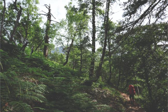
Still within the tree line where forests shade the fierce sun
Climb, scramble, slide
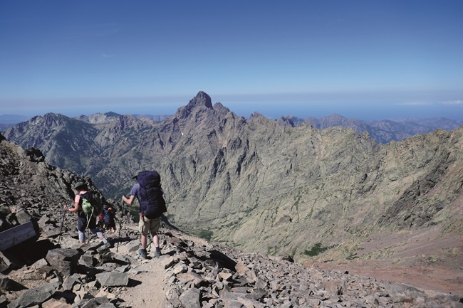
I looked around for the red and white trail blazers. Had I made a mistake? Did I miss a turn? No, there they were, freshly painted red and white markers clearly going up… Up the first boulder, followed by the next boulder and the next until the pile of rocks drew a line at the horizon above.
Corsica’s interior is a lot more mountainous than most people realise. There are more than 400 named mountains on the island, with 20 of them peaking at more than 2,000m. The GR20 follows the mountain range that snakes its way diagonally from the south-eastern corner to the north-west of the island, with a route that requires rather more than just the ability to hike.
I took a deep breath, threw my walking poles up to the next ledge, gripped the rocks with my hands and began to climb. Having repeated this process a few times, I finally reached the top of the rocks. A field of scree paved the next mile – this would not be easy going. It was a furnace by now and I sucked greedily at my water supply hoping I wouldn’t drain it before the end of the day. Still ascending at a sharp incline, I scrambled and slid on stones that were too hot to touch, and made my way, slowly but surely, to the top.
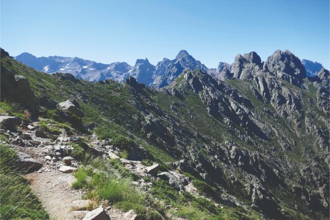
Mountain top views and walking along a ledge
On top of the world
There is no doubt about it: Corsica is beautiful. Yet still, I wasn’t prepared for it to take my breath away at each and every turn. Time after time as I conquered the top of a ridge, I was rewarded with the startling beauty of my surroundings: the horizon dominated by rows of mountains dressed in the dusty olive green of the tough maquis (shrubland) that grows abundant in this harsh environment, and the silver edges of countless granite peaks rising and falling like a line on a seismogram. From pine forests that wind their way around the base of the mountains, cold streams flow into river rapids through waterfalls and natural water pools. Occasionally the bleating of the wild mountain sheep could be heard echoing across the valley; I even saw a pair of peregrine circle the sky.
At Pointe des Éboulis (2,607m), the highest point of the GR20 near the peak of Corsica’s tallest mountain, Mount Cinto, I felt a wave of emotions. My feet were covered in blisters and my hands were sore with bruises and cuts from climbing on sharp rocks; yet from this vantage point, where other peaks seemed to be of no consequence and the sweeping views expanded all the way to the glittering sea, I wanted to laugh, cry and yell all at once. Taking my time to descend the equally vertical drop back to ground level – which was, in fact, even harder than the ascent – I had time to really think about the experience.
I have to say, I echo my friend’s sentiments: I would not call the GR20 a hike either. It is an obstacle course, an adventure and an adrenaline kick. It challenges the body and the mind, exhausting and refreshing you at the same time. Above all, it is testimony to what we are all capable of. And a chance to understand what it means to truly feel on top of the world.
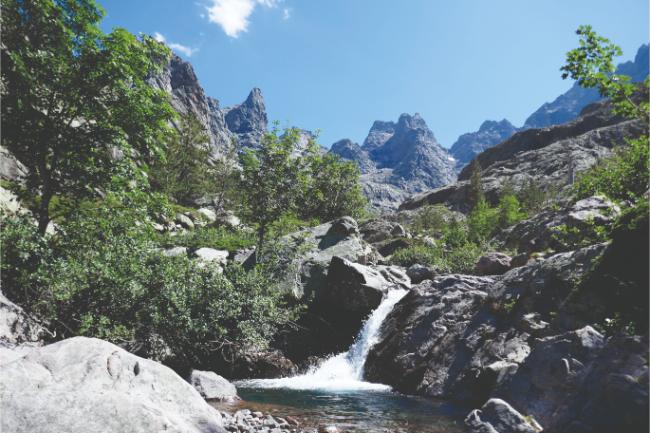
Waterfall along the Manganellu river enroute
HIKING IN CORSICA ESSENTIALS
The GR20 should only be attempted by experienced hikers.
Corsican Places offer packages for self-guided hiking on the GR20. Itineraries can be tailor-made based on choices of sections and number of days, with the option to fly a charter flight with BA Cityflyer from London Stansted direct into Calvi departing every Sunday morning between May 14 and October 1. Packages include return flights, accommodation on the hike with full board, luggage transfers where possible, map and route notes.
CONTACTS
For more information on Corsica, visit www.visit-corsica.com
From France Today Magazine
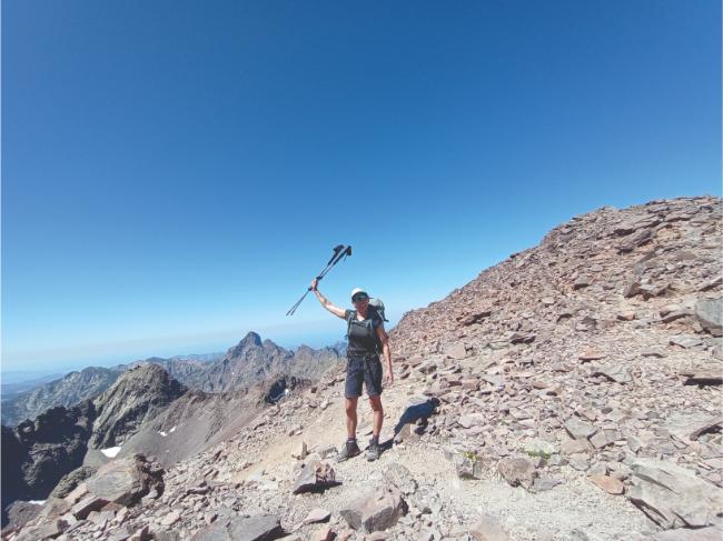
Amy near the summit of Cinto
Lead photo credit : The northern part of GR20 towards Calvi is challenging
Share to: Facebook Twitter LinkedIn Email
More in corsica, French island, hiking, South of France, walking, walking trails
Related Posts
Leave a reply
Your email address will not be published. Required fields are marked *