
The Many Colours of Brittany’s Enchanting Coast
Caroline Mills divides her time between walks along Brittany’s coastal path and driving the coast roads
Tucked behind a salmon pink rock sits a little hut of similarly hued stone. The rock, sculpted by the force of the Atlantic, is so substantial it hides the little hut from the sea. The roofless building has two gable-end windows and a door. From these vantage points customs officers of yesteryear would sit and watch.
The hidden hut sits adjacent to the GR34 long-distance walking route, also known as the Sentier des Douaniers, or Customs Officers’ Path. The 2,000km route stretches along the coast of Brittany and beyond, from Mont Saint-Michel to Saint-Nazaire. It’s a coastal path to rival any in the world – and has been voted France’s favourite long-distance footpath.
The most famous of all Grande Randonnée paths, the sentier was created in 1791 as a route that customs officers would patrol to curb moon-cursers coming ashore and impede the pillaging of shipwrecks. Today it offers one of the most exhilarating ways to view Brittany’s extraordinary coastline. But, without 70 to 100 days to spare, attempting the footpath’s full length in one bite is impossible, so I chose to combine a road trip around Brittany’s coast with a series of walks.
I left Mont Saint-Michel as a robed monk was pulling a bellringer’s rope in the rock-topped abbey, the call to midday Mass resonating across the bay. As pilgrims reached their journey’s end, I was just beginning my navigation of the UNESCO World Heritage-designated bay, passing through stone-housed villages selling roadside vegetables and seaside huts preparing oysters.
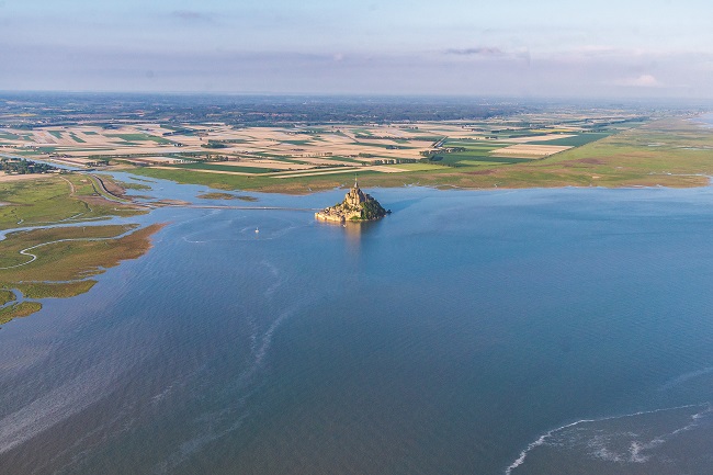
Mont Saint Michel and its UNESCO World Heritage listed bay © Teddy Verneuil Brittany Tourism
A Shape-Shifting Coastline
Through Cancale, I stepped out on foot at Pointe du Grouin, where the needle-like promontory separates the Baie du Mont Saint-Michel from the Côte d’Émeraude. It’s a lovely place for rock scrambling and viewing the Île des Landes, surrounded by the racing emerald currents.
South of Saint-Cast-le-Guildo, I encountered the first significant cliffs, smothered by oak trees whose greenery livened up a monochrome day when the sea was struggling to live up to its jewelled name. Northwest of the town, Cap Fréhel, like Pointe du Grouin, divides two coasts and provides a must-walk section of Brittany’s coastline. Open moorland atop sharp cliffs, with bracken, gorse and heather, provides a different feel and colour from the cliffs at Saint-Cast or the Pointe de Grouin. This exceptional moorland continues on to popular summer resort Sables-d’Or-les-Pins, where scented pines take over.
Passing through Saint-Brieuc, I stopped at the small fishing port of Binic, notable for its quayside restaurants, before walking a section of the GR34 between Saint-Quay-Portrieux and Plouha. At 104 metres, the cliffs here are the highest in Brittany, again smothered by trees rather than heather. Splintered and craggy, they nosedive into the sea along the Côte de Goëlo. One of the finest points from which to view them along the coast path is the Pointe de Plouha or, if you prefer, you could drive the Route des Falaises between Saint-Quay-Portrieux and Paimpol, which follows back roads through hamlets of stone houses, coloured by hydrangeas and the ubiquitous blue doors and shutters.
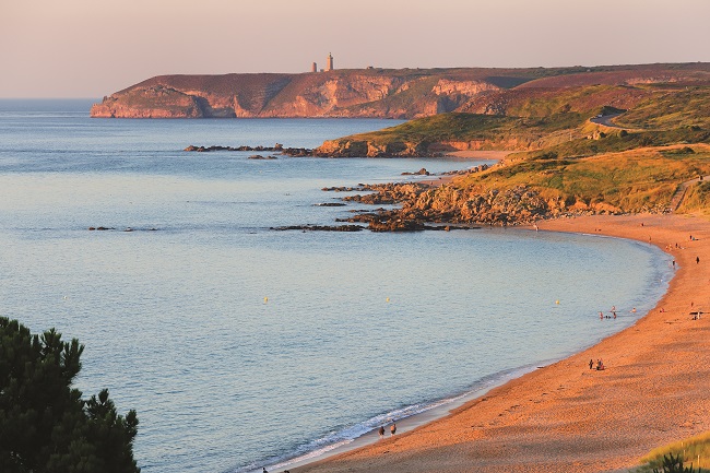
Cap Fréhel at sunset © Yannick Le Gal_Brittany Tourism
Further northwest is the Sillon de Talbert, an extraordinary sand and pebble spit that stretches 3km into the sea and which, in places, is little wider than a human body. The spit was breached in 2019, so a walk to the end needs pacing to avoid getting stuck but, with electric blue sea holly and wild asters for floral company, there’s plenty to occupy the senses for those who do.
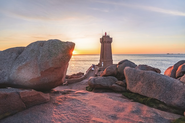
Moving west, Brittany’s north coast was at its most colourful along the Côte de Granit Rose, a spot worthy of extensive walks. I parked up to walk the GR34 from La Clarté to Coz-Pors, where the path cut through sets of pink-flecked giant boulders, like pieces of modern art, the heather, gorse and honeysuckle woven amongst them creating mosaics of colourful backcloth.
These boulders continued further west, not in pink, but nonetheless big and bold. The Côte des Sables, beyond Roscoff, became my next place to step out. From Plouescat, the giant Keremma dune created one huge silky beach, stretching until Brignogan-Plages, where the giants appeared again. Through the Pays Pagan, megaliths, menhirs, and mega stones ‘grew’ among the massive cabbages and wild carrots, with dainty autumnal heads of pink and purple.
In the far northwest, I took the coast road from Portsall along Les Abers, where a series of rivers reach for the sea through rough moorland, carving inlets into the coastline. Turning south, I should have given more time to Le Conquet, with curlews in the bay and a backdrop of horse chestnut woodland, a rare sight along the coast so far. But the wild sea, tossing untamed white horses against the black and shaley rock at the Pointe Saint-Mathieu was too enthralling alongside the colossal red and white lighthouse. With a ruined abbey alongside, there’s a gothic feel to the tempestuous landscape.

The Côte de Granit Rose and its pink-flecked boulders © Caroline Mills
Brooding Beauty
It was a damp start when I passed through Le Faou, a Petite Cité de Caractère that sits at the confluence of two rivers as they enter the Rade de Brest. Travelling through dense woodland to the Presqu’île de Crozon made a change from the heather and gorse of the north: the rain had blackened the tree trunks, the oaks were tinged with autumn, and mist seeped through the treetops. It added to the mystique of the Aulne, fjord-like, with the Pont de Térénez offering exceptional views across the river.
The Crozon Peninsula is a natural regional park, laden with beauty. Its far west, particularly that of the Roscanvel peninsula which juts north into the Rade de Brest, offers some of the wildest and most remote scenery around, a combination of moorland, woodland and jagged cliffs pounded by breakers and punctuated by historic fortifications. It was a fine place to pick up the GR34 again before visiting the Pointe de Pen Hir, where the wind whipped into a frenzy to batter the steep cliffs while below, the inky black and deep marine blue water pummelled little coves.
I’d argue that the Pointe de Pen Hir rivals the Pointe du Raz (which can be seen from Pen Hir) for unruly splendour. But ‘Raz’, and its near neighbour, the Pointe du Van, has the spiritual superiority for feeling like the edge of the world. There is gravitas to the coast path here, among the ruddy stonechats and copper butterflies, a reverence for the landscape. While the official most westerly point of mainland France is the Pointe de Corsen, a little north of Le Conquet, many view the Pointe du Raz as the sacred place to tick off a must-see list. Teasing views of the Côte d’Iroise and Côte de Cornouaille peppered the journey east by road. Extensive creeks and rias push their way inland, creating idyllic panoramas when in full flow and leaving a landscape of muddy sludge as the tide ebbs.
The next extensive stretch of coast road was at Guidel-Plage, where I passed one surf beach and sand dune after another before returning inland to skirt Lorient. Crossing over the Pont Lorois at Étel for a mooch around its beautiful ria and passing the Alignements de Kerzerho (the size of whose megalithic stones dwarf the nearby and more famous Alignements de Carnac), I picked up the coast again at Plouharnel. Here both road and GR34 align to cross the isthmus to the Presqu’île de Quiberon.

Côte de Cornouailles beach at Fouesnant © Thibault Poriel crtb
Wonderful and Wild
Its west coast, the Côte Sauvage, lives up to its name: wild and savage, it is battered by waves, frothing and foaming against the granite, even in fair weather. No Swimming, the signs said. Little wonder when the unforgiving sea drubs everything in its path.
While the Côte Sauvage braved the Atlantic, on the opposite side of the presqu’île, the Baie de Quiberon appeared like sheet glass. Beyond, the narrow entrance to the Golfe du Morbihan cocoons an archipelago of small islands, the largest of which are the Île-aux-Moines and Île-d’Arz. Neither island is included on the GR34, though each offers a coastal walk. I caught a morning ferry from Port Blanc for the five-minute crossing to Île-aux-Moines; circumnavigating the island on foot took four hours, by which time the numerous cafés and restaurants in the cosy town above the harbour had opened for lunch.
The Sentier des Douaniers continues to wiggle around the coastline of Brittany before tripping over into the Pays de la Loire for its final leg, concluding at the Pont de Saint-Nazaire. I, however, finished my journey before the regional boundary with a final walk at the Pointe de Penvins, one of the last headlands along the coast, in the southeast of the Rhuys Peninsula. To the west, the Anse de Suscinio offered a long promenade from the remarkable Château de Suscinio; to the east were the sandbanks of the no less remarkable Penerf ria and Penerf Peninsula.
As I stood looking out over the point, the red sails of sinagots – Brittany’s traditional south coast sailing boat – drifted by in the bay. From the flower-strewn rocks and cliffs to the maritime hues of the sea and the boats that sail on it, Brittany’s coast has many colours.
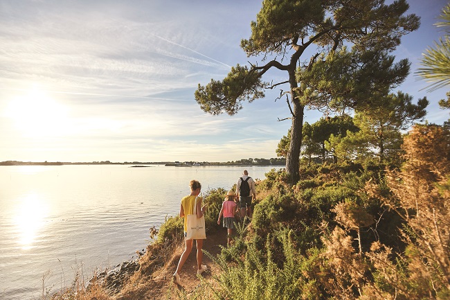
Walk the coastal path in Quiberon bay © Alexandre Lamoureux crtb
From France Today magazine
Read more about Brittany:
The Littoral Charms of Brittany
Travel Notes: Four Favourite Lighthouses in Brittany
For more information to plan your trip to Brittany, visit www.brittanytourism.com
Lead photo credit : The Men Ruz lighthouse on the Côte de Granit Rose © Thibaud Poriel
Share to: Facebook Twitter LinkedIn Email
More in Brittany, French coastal holidays, roadtrip, walking
Related Posts

Leave a reply
Your email address will not be published. Required fields are marked *